
Day 8: Monday, August 27, 2018
Route: Osoyoos, BC, to Hood River, OR
Woke up around 5:30 a.m. because my Couchsurfing hosts were leaving at 6. The sun was just coming over the mountains east of town. I made sure both kidneys were still there, loaded up the bike, and got ready to go. I said goodbye and thanked my hosts for their hospitality and headed to Timmy’s for breakfast before heading for the border.
I started my ride south before 7 a.m. There was no traffic on the road and nobody in line at the border station in Oroville, Washington. I cleared through customs and headed south on US Highway 97.

A few miles into the States, I turned onto a side road that paralleled Highway 97 on the west side of the Okanogan River. This road flowed through farm land taking many twists, turns, ups, and downs. I rejoined Highway 97 when the road ended at Tonasket.
Highway 97 wound its way south through the Okanogan Valley, with the view interspersed with the brown foothills of the Cascades and adjacent Kettle Mountains and the green farms lining the Okanogan River.
The Okanogan met the Columbia near Brewster and the road entered into a canyon, following the Columbia as it flowed into Lake Pateros, impounded by Wells Dam. Wells Dam provides hydroelectric power to several communities around Washington and Northern Oregon. I stopped for a break at the dam information center.


Northeast of Chelan, I turned onto US Highway 97 Alternate. “Alt 97” is a nearly 40-mile-long route that splits off the main highway near Wenatchee and winds along the south shore of Lake Chelan and into Knapp Coulee before following the west bank of the Columbia and meeting up with US Highway 2 at Sunnyslope, Washington.
I turned onto Highway 2, which shared an alignment with Highway 97 and headed west. As I approached the city of Cashmere, Washington, I saw a sign for the 9/11 Spirit of America Memorial. I was surprised to see a memorial to the events of 9/11 this far west. Having served in the Army after 9/11, I decided to make a stop.

The memorial had a bit of a troubled history, being rejected by other Washington cities, including the capital Olympia, before being given a home in Cashmere. The memorial is centered around a sculpture made from steel from the World Trade Center and a concrete block from the Pentagon. A circle of bronze statues – a firefighter, flight attendant, office worker, and member of the military – stand facing outward in a circle in front of an American flag. Today the flag was flying at half staff for the death of Senator John McCain. Though the memorial is next to a park with a children’s playground, the memorial itself was quiet, allowing visitors to reflect on the tragic events and the lives lost on 9/11 and in the ensuing military actions in Iraq and Afghanistan.


As I continued west, I decided to take a short detour to Leavenworth. Leavenworth is a Bavarian-themed town nestled in a canyon along the Wenatchee River. The town is a popular spot in winter time when it is decorated and lit up for Christmas, and as a base for skiers going to Stevens Pass.

I grabbed myself a kielbasa at Rudloofs Pizza Und Brats. I got there about a half hour before they opened, so I waited patiently outside. I was customer number one for the day. $8 gets you a quarter-pound sausage covered in sauerkraut and a bag of chips. The kielbasa had just the right amount of spice and was a good lunch.


I left Leavenworth and headed east to get back on Highway 97. Highway 97 wound its way through Blewett Pass. After several miles of twists and turns, the green forests gave way to the brown, grassy Columbia Plateau, dotted with giant wind turbines.
The Kittitas Valley Wind Farm, as it is named, covers more than 6,000 acres and has 48 turbines installed. Overlooking the city of Ellensburg, Washington, the farm produces more than 100 megawatts of energy, which is enough to power 26,000 homes each year. The turbine’s towers are 262 feet tall from the base to the hub, and the blades are each more than 100 feet long and weigh about 7,000 pounds. While writing this, I learned there was a visitor center offering tours. Maybe next time.
After reaching the floor of the Kittitas Valley near Ellensburg, I turned onto Washington Highway 821. I had seen Highway 821 on my map and was immediately drawn to its many curves contrasting with the gentle sweeps of Interstate 82 to the east.
Highway 821, named as the Yakima River Canyon Scenic Byway, runs for 25 miles between Ellensburg and Selah. The highway is an old alignment of Highway 97, which was bypassed in the 1970s. Along the are many recreational spots where you can fish, swim, or camp. I chose to keep going.

Looking at the walls of the canyon, you get a sense of the long geologic history of the area. Layers upon layers of volcanic rock laid down over the ages. According to one of the historical markers in the canyon, the area was once a vast plain of rolling hills. Twenty-five million years ago, the first lava flows covered the land. Streams and lakes reformed and the cycle continued again for the next 15 to 20 million years. The visible layers in the canyon are part of one of the largest lava fields in the world, covering large swaths of Washington, Oregon, and Idaho.
At Selah, Washington, where Highway 821 emerged from the canyon, I turned onto US Highway 12 and headed west. This portion of Highway 12 was known as the White Pass Scenic Byway. I think scenic was an understatement. The road was downright gorgeous.


The White Pass Byway starts at the confluence of the Tieton and Naches Rivers below beautiful brown bluffs that look like they’d be just at home in the deserts of Utah or Arizona. I really had no idea the vast range of geographies I would see in Washington. The byway follows the Tieton River, at time inches from the edge, through a narrow canyon as it climbs toward White Pass. The entire way, giving a contrast between the dark greens of the foliage along the river and the brown hills above. Several campgrounds and day-use areas dot the banks of the river. Just west of the summit, the Tieton River is impounded by Tieton Dam – a 319-foot-tall concrete and earth dam – forming Rimrock Lake.
Near the summit of White Pass, I was graced with an amazing view of the Clear Creek Valley. The deep valley, though covered in trees instead of exposed rock, was vaguely reminiscent of views in Yosemite National Park. On the initial descent from the summit, I stopped at the viewpoint for Mt. Rainier. I could see where Rainier was, but unfortunately, most of the mountain was shrouded in clouds.


When I reached Randle, I turned south onto US Forest Service Highway 25. FS Highway 25 meanders along the east side of Mt. St. Helens. The road was mostly good, but there were a lot of portions where the underlying earth was slipping away, requiring riders and drivers to keep an eye out for rim-bending dips. Along the way, I passed many bicyclists coming down into the Randle area. I wanted to take FS Highway 99 to the Windy Ridge Viewpoint to look at Mt. St. Helens, but given it was getting late in the day, and my posterior was sore from the long ride, I felt a 32-mile round-trip addition to my day was not in my best interest, given I was still 80 miles from Hood River, Oregon. Instead, I was presented with many turnoffs with stunning views of St. Helens.
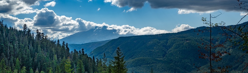


I turned onto NF Highway 90 near Swift Lake and then onto Curly Creek Rd. which climbed a ridge before heading down toward the Columbia River. I stopped at the McClellan Overlook which had a panoramic view of Mt. St. Helens and the surrounding lands. Parked at the overlook was a Ducati ST4. The owner must have worn himself out with riding around the area, because he was taking a nap on a picnic table. Curly Creek Rd. dropped onto Wind River Rd., and wonderful serpentine route with many tight twists and turns that dropped me onto Washington Highway 14 at Carson.


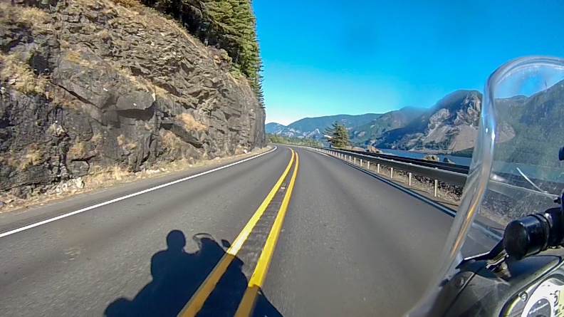

I took Highway 14 east a few miles to the Hood River Bridge crossing at White Salmon. After being on the road for 11 hours, my knees and butt were in some serious need of relief. I decided I’d cross over to Hood River and look for a hotel room for the night. I felt I deserved it.
I knew what to expect this time with the Hood River Bridge’s steel grate deck. Adding to the fun was a crosswind blowing upriver that was doing its best to push me into oncoming traffic.
I booked an “Express Deal” through Priceline and got myself a room at the Holiday Inn Express. The desk clerk was kind enough to let me leave my bike parked in the covered area in front of the main entrance. I got myself a cold can of Angry Orchard from the gas station next door to the hotel and took a relaxing dip in the hot tub to ease my tired muscles and joints. After almost 440 miles, by far my longest day ever on a motorcycle, I wasn’t sure if I ever wanted to ride that long again. A hot shower and comfortable bed capped off the day.
Distance: 437 miles, 1,839 total