
I originally wrote this piece in November 2006 for my university magazine writing class.
I participate in a hobby called geocaching. Geocaching is something of a 21st-century treasure hunt. People hide small objects – bottles, Tupperware containers, ammo cans – in various places and post the geographic coordinates on the geocaching.com web site. Cache hunters then use Global Positioning System receivers to locate these items. Essentially geocaching can be described as using multi-billion dollar military technology to find Tupperware hidden in the woods.
There’s not really any sort of prize or competition involved, the reward is in the journey.
I had been wanting to find a unique cache for a while. Most of the caches in our neck of the woods in Humboldt County were pretty simple. Park here, walk here, the cache is hidden in the hollow part of the log. Big whoop! Give me something interesting.
I searched the geocaching.com database and found one that seemed very interesting. The cache was hidden on an abandoned highway bridge in Shasta County. The bridge was part of the old US Highway 99 and was less than a mile from its Interstate 5 replacement. It was practically hidden in plain sight.
I had to go there.
This cache contained two things that I enjoy: geocaches and old roads. Yes, I am a road geek. I find roads fascinating from a historical standpoint. I’ll notice spots along a highway where a newer section was built to bypass an old section. Today, we’re so used to our eight-lane, wide-open expanses of blacktop, I like to see how things were when times were slower and people took time to enjoy the view on their trips.
But how did this bridge come to be left to die in the shadow of its newer sibling? The story of this bridge starts with the creation of the first national highway system.
Ever since cars were invented Americans have had a fascination with the open road. Once cars started rolling off assembly lines we were no longer tied to trains, horses or other forms of land transportation. With ever-increasing numbers of car owners, states started creating their own road systems so people could get from point A to point B.
Something changed in 1926. At that time, there were all these roads, but how do you get to point B if it is in two states away, or even across the country? The nation’s road network was a mishmash of state highways with no clear pattern or numbering system. It was mass confusion. This is where things changed. In 1926, the US Federal Highway system was created. The US highway system was the precursor to today’s Interstate Highway system. This is the system gave birth to such famous roads as Route 66 and Highway 101.
The system created a common numbering system for highways. The reasoning was that if people could go from Point A to Point B on the same numbered road, there would be less confusion and people could get to their destination quicker. For example, one could drive from Chicago to Los Angeles just by taking Highway 66. It was a brilliant system and it made sense.
It was also in 1926 that the main road along the West Coast was created. This road went from Calexico, Calif., on the US-Mexico border all the way to Blaine, Wash., on the US-Canada border – nearly 1,500 miles. Along its path, it passed through Los Angeles, Sacramento, Portland, and Seattle. It was US Highway 99. This road remained the main North-South road on the West Coast until 1964 when Interstate 5 was completed. Ironically, Interstate 5 follows much the same route as Highway 99.
Highway 99 was one of the roads made famous in John Steinbeck’s The Grapes of Wrath. It was the last road the Joads took down into the fertile valley at the end of their journey to escape the dust bowl.
One thing that set these highways apart from their Interstate replacements was that they allowed you to see America. Because many of the routes were not straight lines like the Interstates you saw many of the small towns and natural wonders that dot the American landscape. Alternately, Interstates allow you to go from point A to point B without stopping at higher speeds leading to a bland trip where all you see is the road. You get there quicker, but you miss out on much of the beauty that is America.
Furthermore, one thing these highways had that today’s interstates don’t is beautiful architecture. Through mountainous areas and over rivers you could find some of the most beautiful bridges and roads ever created, a far cry from today’s utilitarian roadways. Much of this road system was built for form as well as function. The roads blended into the landscape so much that they looked like they had been there since the beginning of time.
Alas, US Highway 99 was decommissioned in 1968, leaving much of the road to rot away in the shadow of Interstate 5, though a large section of old 99 still exists in Central California as State Highway 99.
I wanted to find part of this old highway. I wanted to see architecture that just doesn’t get made today. This geocache would let me find a part of that rotting highway.
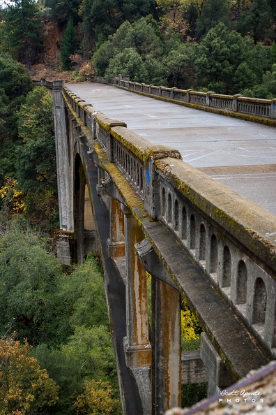
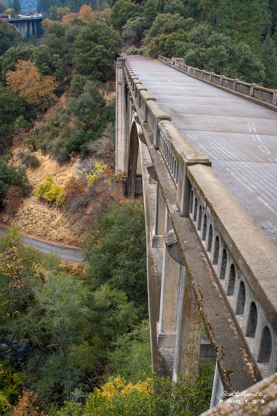
Officially the bridge’s name was the Harlan D. Miller Memorial Bridge. It was built in 1926 and was named after the former head of the California Department of Bridges and the bridge’s designer. Oddly enough, Miller was so revered by his peers and those who worked for the department that the replacement bridge on I-5 was also named in his honor.
The bridge was placed on the National Register of Historic Places in 1984. Many people regarded it the work of a master as Miller had taken a large role in designing and building the bridge. It was not only functional, but was a work of art, built during a time when structures were built for beauty and for use. Many people say the Miller Bridge is one of the most artistic and amazing bridges ever built in California, though others like the Golden Gate and Bixby Bridges get all the attention.
I exited I-5 a few miles north of Riverview, Calif., just past the northern tip of Shasta Lake. I drove down an empty unmarked road that had a very unfriendly looking sign marked “Private Property.” Though it said Private Property, the listing assured me the road itself was public. Besides, the two houses I passed looked abandoned, I was pretty sure I would not be bothered. However, it added an element of danger to the trip.
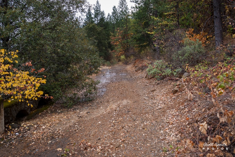
I reached the end of the pavement and was presented with a forked dirt road. One direction would take me down to the river; the other would take me along a cliff with no guard rail to the bridge. This dirt road was the old highway.

I maneuvered my Honda Civic down the road at less than 5 miles per hour, I avoided ruts that would swallow the front end and steered around rocks that had fallen from the cliff face that was cut to make way for the road.
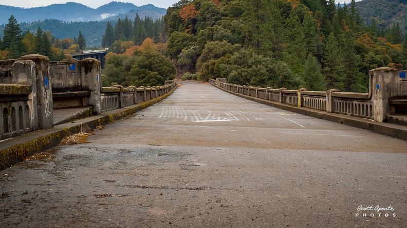
The pavement that used to be the old highway was no longer there, swallowed by time and years of neglect. However, signs of the old highway still remained, like a portion of the old stone arch guard rail that kept travelers from falling into the ravine below. The road looked barely wide enough for one direction of traffic. I can see why it was replaced.
I turned a bend in the road and I saw it. The bridge was there in all its beige and black glory. A concrete bridge at the end of a dirt and clay road looked out of place. The red clay contrasted sharply with the beige bridge.
A first look at the bridge showed me that it was unique among the bridges of the era. The guard rails were adorned with bright blue tiles that, despite being 80 years old, still look as bright as the day they were installed. Furthermore, there was something on the guard rails that you don’t see on bridges … anywhere. There were benches.


Forged from the very same concrete as the rest of the bridge were two benches at each end. Life moved slower back then. People weren’t in such a hurry to get to where they were going. Benches allowed travelers on 99 to rest a while and take in the beautiful scenery of the area. On one side, a river snaking through a deep canyon, on the other, the lush, green mountains. The benches were every bit a sign of a bygone era.
I walked across the bridge. It still felt solid; the mark of a quality feat of engineering (though I’m sure my 230 pounds were a mere pittance compared to the weights this bridge was designed to hold). The description of the bridge said it was still safe to drive on. Surely, they did not have the construction technology we have now, but like the ancient Romans they built things to last. How else would so many decades of neglect not relegate such an edifice to a pile of rubble at the bottom of the ravine?
Despite the bridge’s sturdiness, the years had taken a toll on it. Many of the surfaces of the guard rails and curbs were covered in moss. Fifty years of vandals had left 50 years of marks all over the bridge – “SO I’M ANTI SOCIAL” … “PMC.” I wonder how long it took after the bridge closed for the vandals to move in. The bronze identification plaques installed at both approaches to the bridge were even missing.
I reached the south side of the bridge. It was here, hidden among the ever encroaching foliage, that I found the hidden geocache. It was a simple item, a large vitamin bottle covered in camouflage tape so you would not see it if you were not looking for it. There was not much inside to trade for, so I left a travel bug (travel bugs are uniquely numbered items the users can track on its journey around the world), signed the log book and replaced the bottle where I had found it so another 21st-century treasure hunter could find it upon his discovery of this location.
I walked past the end of the bridge, following the old roadway south. No more than a few steps from the end of the bridge the pavement disappeared and turned into more red clay. I looked down the old road, trying to visualize where it went from here, only to see its remains fade into the green forest as if it were a botanical version of a black hole. The road was cut from the forest and the forest was taking it back.
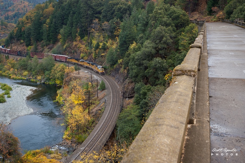
I snapped some pictures of the road fading into the green oblivion, got a shot of the old and new – the original bridge in the shadow of its modern replacement. I walked along the sidewalk taking peeks over the edge into the ravine below. A set of railroad tracks appeared from behind a hill, turned parallel to the bridge and then disappeared behind another hill. A train passed by, blaring its horn at the old bridge. Dog Creek, the stream that passed under the bridge, gurgled along its southerly route, its waters destined to wind up in Shasta Lake some 10 miles south.

I stepped up onto one of the old benches and leaned over to get a look at the bridge’s magnificent arch. Its 250-foot arch was once one of the longest in California. The arch had turned black from time in some places. Its columns had red streaks from rust that has seeped through the concrete from the steel inside. It was like the roadway was crying red-orange tears because such a beautiful piece of architecture was being allowed to waste away.

After taking in all the beauty this location had to offer, though I’m sure if I went back I’d find something else wonderful to look at, I carefully maneuvered my car around the old roadway again to get back to I-5 and head home. I merged back onto the freeway among the 18-wheelers and cars that fly by at 70-plus miles per hour without so much as a glance at nature’s wonders that surround them. I glanced off to my left and through the trees I could see flickering images of the old Miller Bridge nearly invisible if you aren’t looking for it. There it was, hidden in plain sight, the past in the shadow of the present longing to be seen and remembered. The bridge would remain and await its next visitor and, just as its flickering images did to me, it would thank them for the visit and ask them not to forget this hidden beauty.
Since I wrote this piece, Caltrans has ceded the access road to the owner of an adjacent property. The property owner has stopped keeping the road clear and will confront anyone trespassing on the property.